GIS_LINE: Building a JSON Line
|
How to: |
Given two geometry points or lines, GIS_LINE builds a JSON line. The output is returned in text format.
Syntax: How to Build a JSON Line
GIS_LINE(geometry1, geometry2)
where:
- geometry1
-
Alphanumeric or text
Is the first point or line for defining the beginning of the new line.
- geometry2
-
Alphanumeric or text
Is the second point or line for the concatenation of the new line.
Example: Building a JSON Line
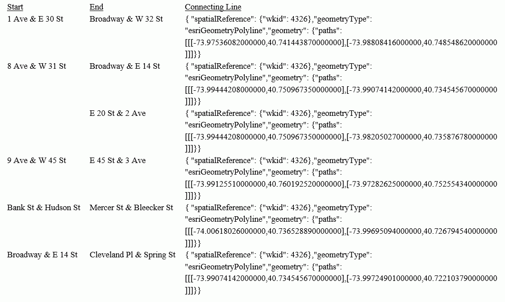
The following request prints start stations and end stations and builds a JSON line between them.
DEFINE FILE ESRI/ESRI-CITIBIKE
STARTPOINT/A200 = GIS_POINT('4326', START_STATION_LONGITUDE, START_STATION_LATITUDE);
ENDPOINT/A200 = GIS_POINT('4326', END_STATION_LONGITUDE, END_STATION_LATITUDE);
CONNECTION_LINE/TX80 (GEOGRAPHIC_ROLE=GEOMETRY_LINE) =
   GIS_LINE(STARTPOINT, ENDPOINT);
END
TABLE FILE ESRI/ESRI-CITIBIKE
PRINT END_STATION_NAME AS End CONNECTION_LINE AS 'Connecting Line'
BY START_STATION_NAME AS Start
WHERE START_STATION_NAME LE 'D'
ON TABLE SET PAGE NOLEAD
ON TABLE SET STYLE *
TYPE=REPORT, GRID=OFF,$
ENDSTYLE
END
The output is shown in the following image.
| WebFOCUS | |
|
Feedback |