GIS_POINT: Building a Geometry Point
|
How to: |
Given a WKID (Well-Known ID) spatial reference, longitude, and latitude, the GIS_POINT function builds a JSON point defining a Geometry object with the provided WKID, longitude, and latitude. The function is optimized for those SQL engines that can build a JSON geometry object.
The field to which the point is returned should have fixed length alphanumeric format, large enough to hold the JSON describing the point (for example, A200).
Syntax: How to Build a Geometry Point
GIS_POINT(wkid, longitude, latitude)
where:
- wkid
-
Fixed length alphanumeric
Is a spatial reference code (WKID). WKID is an abbreviation for Well-Known ID, which identifies a projected or geographic coordinate system.
- longitude
-
D20.8
Is the longitude for the point.
- latitude
-
D20.8
Is the latitude for the point.
Example: Building a Geometry Point
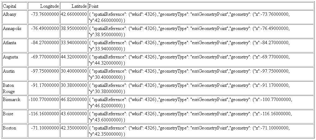
The following request uses the spatial reference code 4326 (decimal degrees) and state capital longitudes and latitudes to build a geometry point.
DEFINE FILE WF_RETAIL_LITE
GPOINT/A200 = GIS_POINT('4326', STATE_PROV_CAPITAL_LONGITUDE, STATE_PROV_CAPITAL_LATITUDE);
END
TABLE FILE WF_RETAIL_LITE
SUM FST.STATE_PROV_CAPITAL_LONGITUDE AS Longitude
FST.STATE_PROV_CAPITAL_LATITUDE AS Latitude
FST.GPOINT AS Point
BY STATE_PROV_CAPITAL_NAME AS Capital
WHERE COUNTRY_NAME EQ 'United States'
WHERE STATE_PROV_CAPITAL_NAME LT 'C'
ON TABLE SET PAGE NOPAGE
END
The output is shown in the following image.
| WebFOCUS | |
|
Feedback |